Data Analysis and Findings
In this page, there was a review of the objectives of the research. The Points of Interest, Profile, Land Use, Buffer, and Population Analysis was carried out. The analysis will be further examined in the paragraphs below.
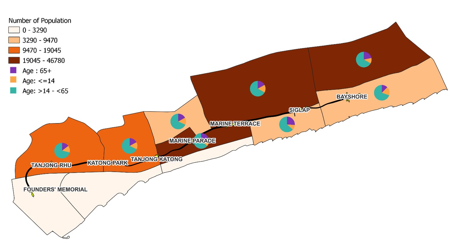
Population Analysis
Station Name |
Young |
Middle |
Aged |
Total |
|---|---|---|---|---|
Founder’s Memorial (Marina East) |
0 |
0 |
0 |
0 |
Tanjong Rhu |
1,580 |
7,910 |
1,630 |
11,120 |
Katong Park & Tanjong Katong (Mountbatten) |
1,490 |
6,800 |
1,710 |
10,000 |
Marine Parade |
3,890 |
17,160 |
5,920 |
26,970 |
Marine Terrace & Siglap(Frankel) |
5,560 |
23,110 |
5,880 |
34,550 |
Bayshore (Bedok South) |
5,320 |
31,260 |
10,200 |
46,780 |
We have categorized population into three groups for the analysis, namely, the young for those less than or equal to 14 years old, the adults for those aged 14 to 65, and lastly the elderly who are more than 65 years old. The map also displays population density with different tones of beige (less populated) to dark brown (densely populated).
It can be observed that the areas around Marine Parade, Marine Terrace, and Bayshore are densely populated, while the areas around Founders' Memorial, Katong Park and Tanjong Katong are less densely populated.
Potential property buyers looking to buy and stay in a property along the TEL Stage 4 line can consider settling down in areas around Tanjong Rhu, Katong Park and Tanjong Katong if they prefer serenity. On the contrary, if they prefer residing in lively areas, areas in Marine Parade, Marine Terrace and Bayshore would suit their lifestyle better.
Many of the residents along TEL Stage 4 line are adults aged 15 to 65, as we can observe that they took up the largest area on all the pie charts. Developers can relook into the facilities around the area, to determine if there are enough amenities to meet their lifestyle needs. Siglap has the largest elderly population in comparison with the rest, and this would imply that it is recommended to assign more healthcare facilities to meet the aging population in the area around Siglap.
Points of Interest Analysis
The results enabled us to find out the characteristics of each station. There are four (4) types of MRT stations: Education Centric, Transport Centric, Health Centric, and Lifestyle Centric. The table below shows the deciding factors.
Centric Type |
Formula |
|---|---|
Education Centric |
A = Preschool Count + Primary School Count + Secondary School Count |
Transport Centric |
B = Taxi Stops Count + Bus Stops Count |
Health Centric |
C = Clinic Count + Elderly Care Count |
Lifestyle Centric |
D = Bank Count + Supermarket Count + Mall Count + Food Count |
Total Count = Centric Type = max (A, B, C, D) |
Each MRT Station’s centric type was decided on the formula with the highest sum.
MRT Station Name |
Centric Type |
|---|---|
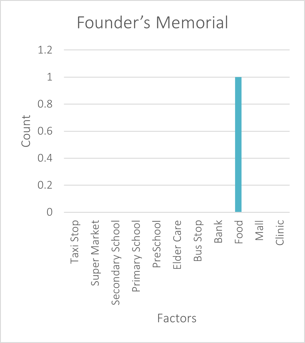
Founders’ Memorial |
Lifestyle Centric (Total Count: 1) |
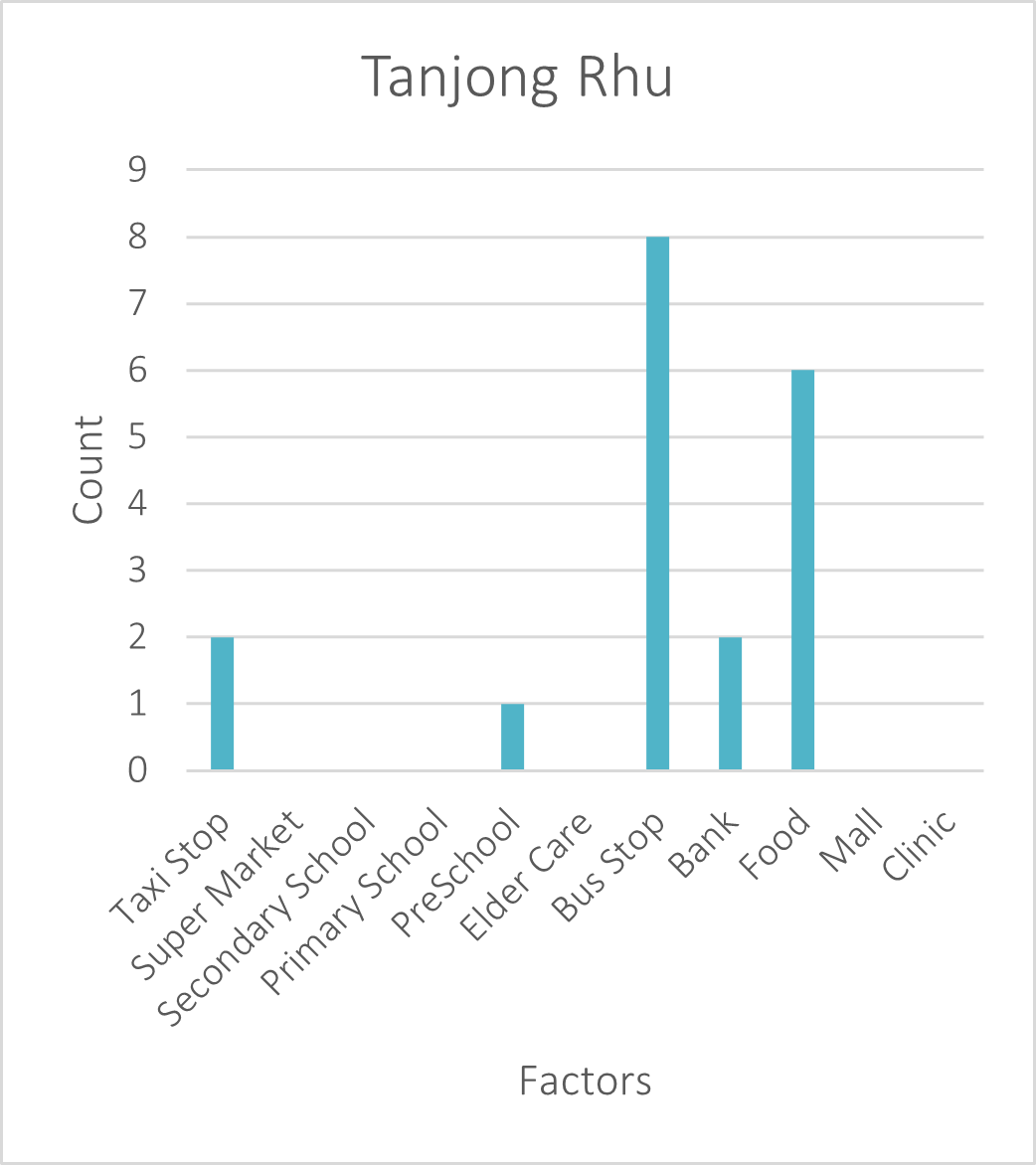
Tanjong Rhu |
Transport Centric (Total Count: 10) |
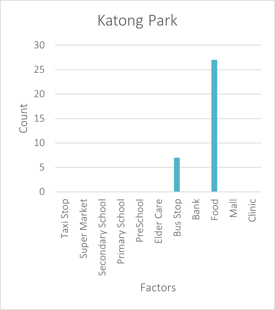
Katong Park |
Lifestyle Centric (Total Count: 27) |
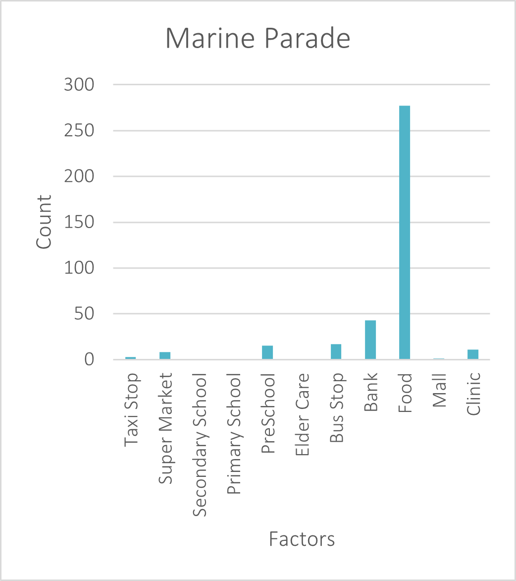
Marine Parade |
Lifestyle Centric (Total Count: 329) |
Marine Terrace |
Lifestyle Centric (Total Count: 150) |
Siglap |
Lifestyle Centric (Total Count: 25) |
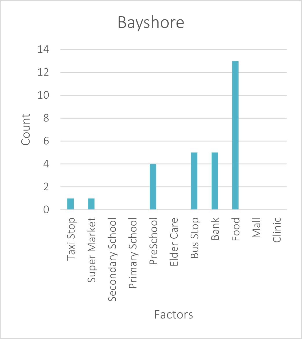
Bayshore |
Lifestyle Centric (Total Count: 19) |
Marine Parade has the highest sum of Banks, Supermarkets, Malls and Food spots, amounting to a total count of 329 as shown in Table 6. Marine Terrace came in second place with a total count of 150. Additionally, Katong Park comes in third place with a total count of 27.
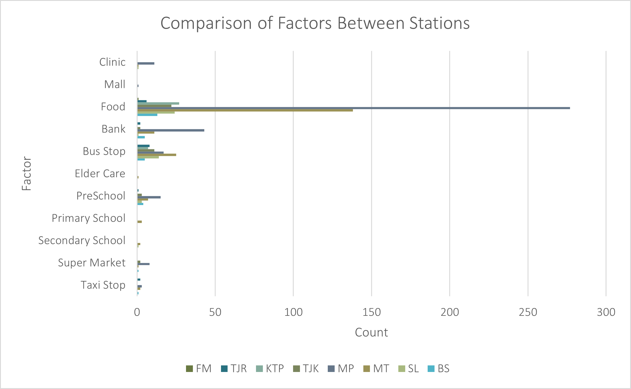
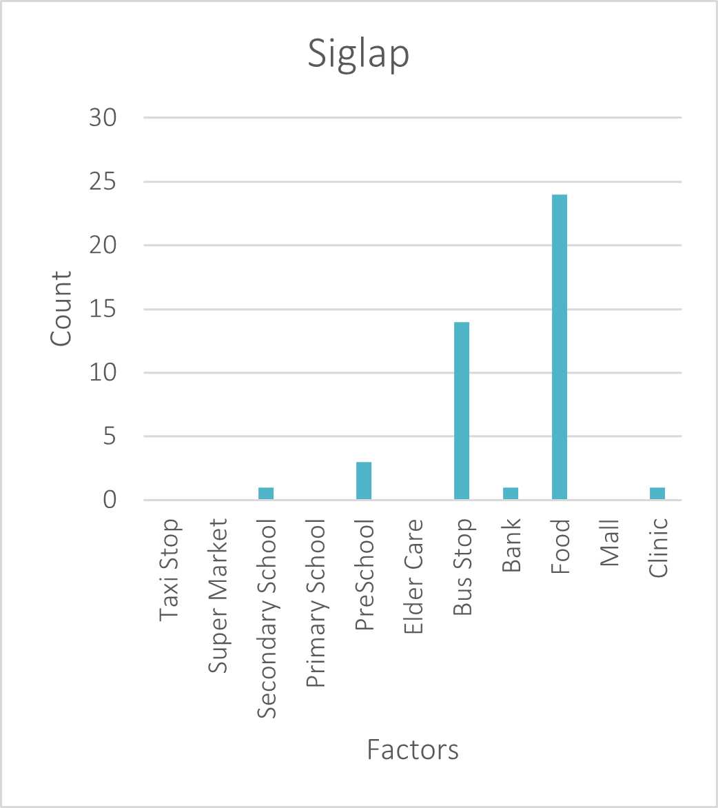
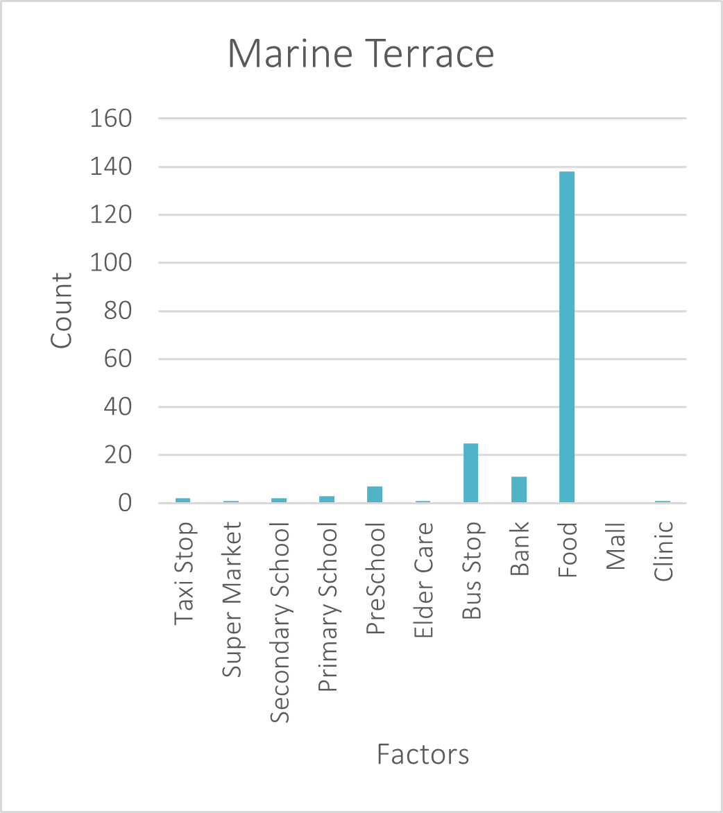
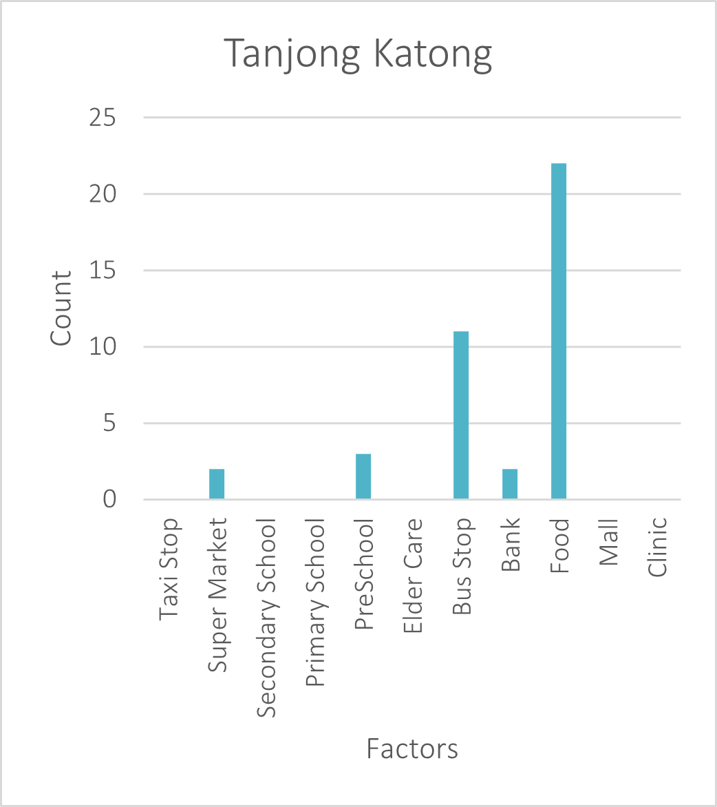
The chart above shows that Marine Parade and Marine Terrace are the two liveliest areas with the highest number of facilities to meet the needs of all the different age groups. Based on the 8-barchart as shown below, it is clearly shown that food factor is generally the most common factor within the 10 mins walking distance range.
 |
 |
|---|---|
 |
 |
 |
 |
 |
 |
Voronoi Polygon
The figure below shows the Voronoi Polygons based on the centroid points of each MRT Station layout. Every point within each Voronoi piece is closer to that MRT station than any other piece on the map.
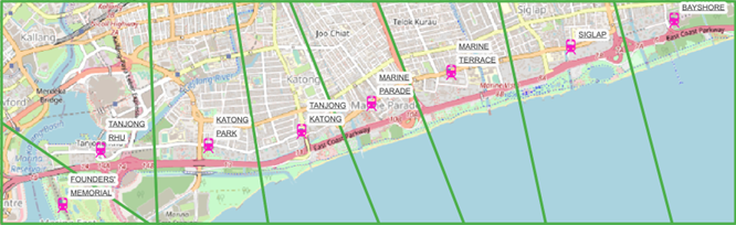
The Voronoi Polygon analysis helps us understand the MRT station that is the closest to any of the points analysed. Secondly, it also helps to understand each MRT stations’ area of influence.
Land Use Analysis
Singapore's Urban Redevelopment Authority will release a new Land-Use Master Plan (MP) every five years. The medium-term development of Singapore during the next 10 to 15 years is governed by the legislative land use plan. The latest version was published in 2019 and URA_MP19_SUBZONE_NO_SEA_PL has been used for this project
Founder's Memorial
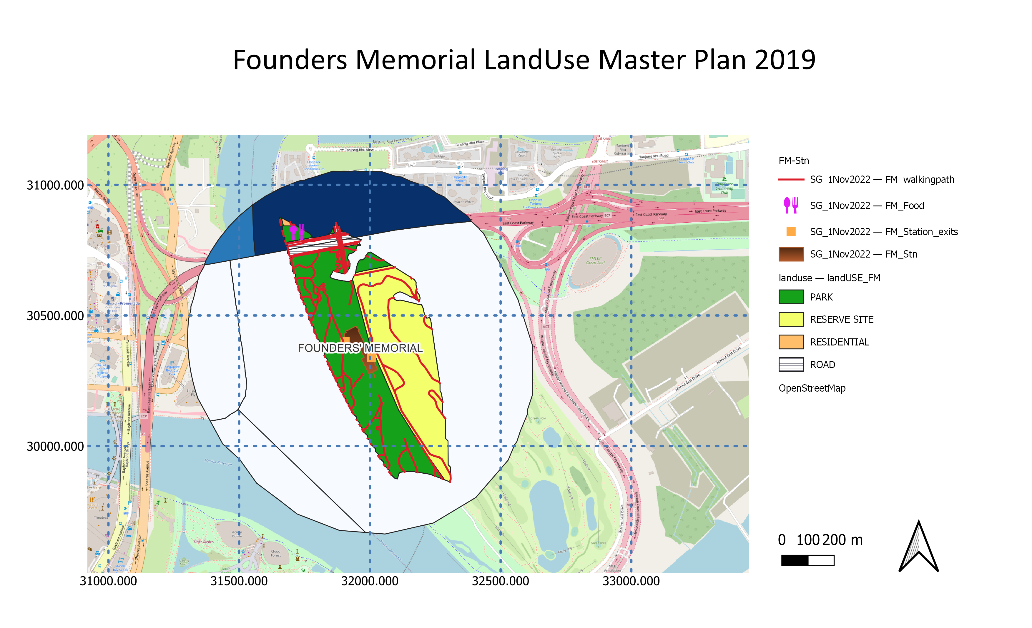
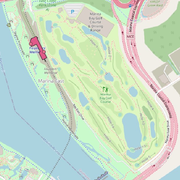
FM station is built near Gardens by the Bay which brings railway connectivity in supporting the future development around the central region. After analysis, we found out that there are limited amenities around the FM area. Based on research, we found that the Marina Bay Golf Course lease would be expiring in July 2024. In 2019 URA's Master Plan, the area has been marked as a reserved site and the specific use of land has not been determined.
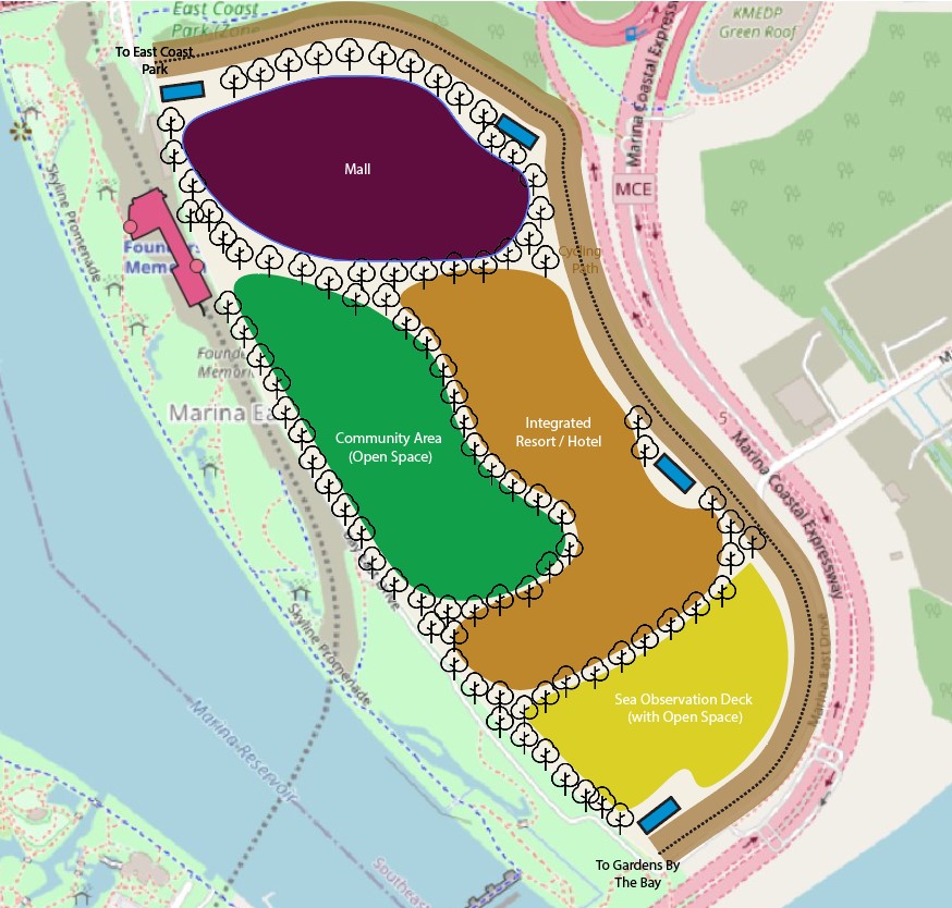
The government expressed that they do not have any intention to approve any extension of the lease and announced that the land be put to other uses. Therefore, our group has come out with a recommendation to aid URA in planning the redevelopment of Marina Bay Golf Course's 68 hectares land plot. Since the location is strategically located beside Gardens by the Bay, more tourist spots could be developed to complement Gardens by the Bay and Marina Bay Sands area. These include malls with retail, food and beverages options, sea observation area and possibly an integrated resort with more hotel rooms to cater for the potential increased volume of tourists. A community area can also be built to allow tourists to have a taste of the traditional culture of Singapore, sharing Singapore's history, food, and games. Costume rental can be integrated into the community area to allow tourists to rent our multicultural costumes and take pictures in them. Additionally, some office buildings can also be built, housing many grade A offices with spectacular views of Marina Bay, further boosting Singapore’s economy.
Rejuvenation of Marina Bay Golf Course's Land Area
|
Current Land Use of Marina Bay Golf Course |
Proposed Land Use of Marina Bay Golf Course |
 |
 |
Tanjong Rhu
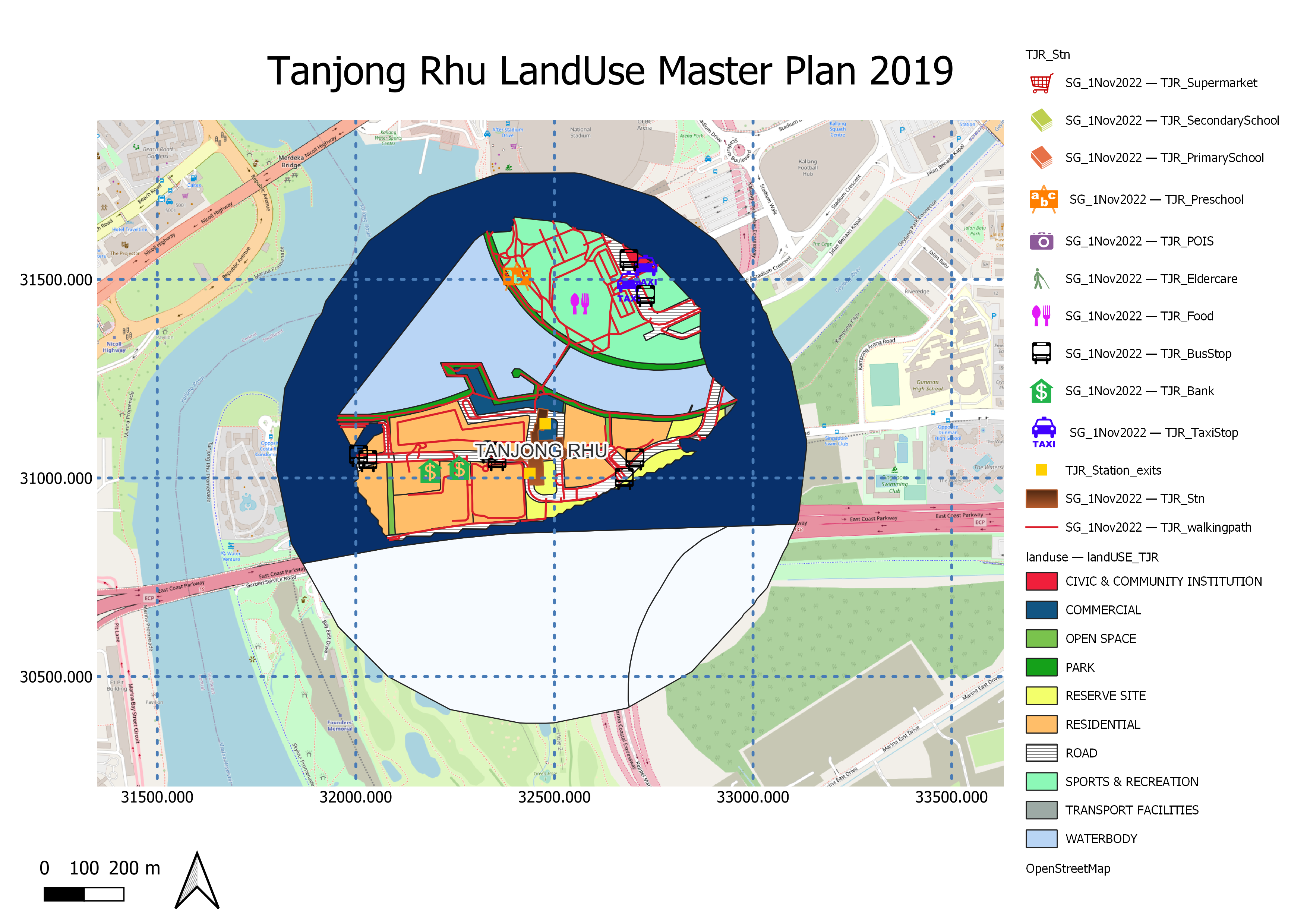
TJR is an underground station which is located near Tanjong Rhu estate and Singapore Indoor Stadium. After analyzing the land use, we noticed that the residential areas have limited food and supermarket choices that were far from residential areas. This implies that residents must take long walks to get their food or drive. We recommend that a small shopping mall to be built on top of the stations so that residents can purchase their necessities within closer proximity.
Katong Park
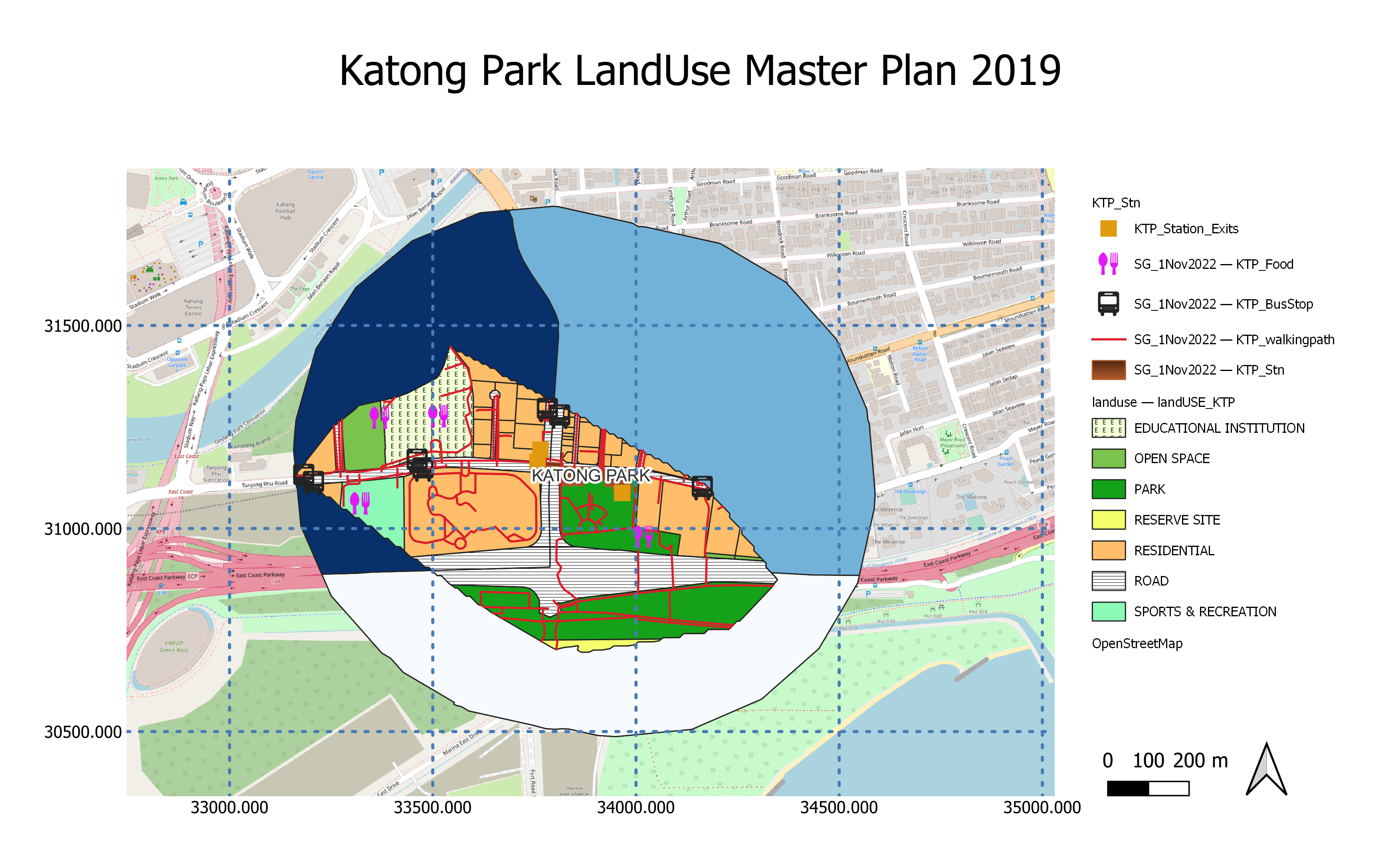
The area of the KTP station is in the vicinity of a park, school, and many residential areas. Like TJR station, we noticed that this residential area has few amenities. As compared to TJR, there is a much higher residential land area. We also recommend that a small mall be built on top of the station so that residents can purchase their necessities within closer proximity.
Tanjong Katong
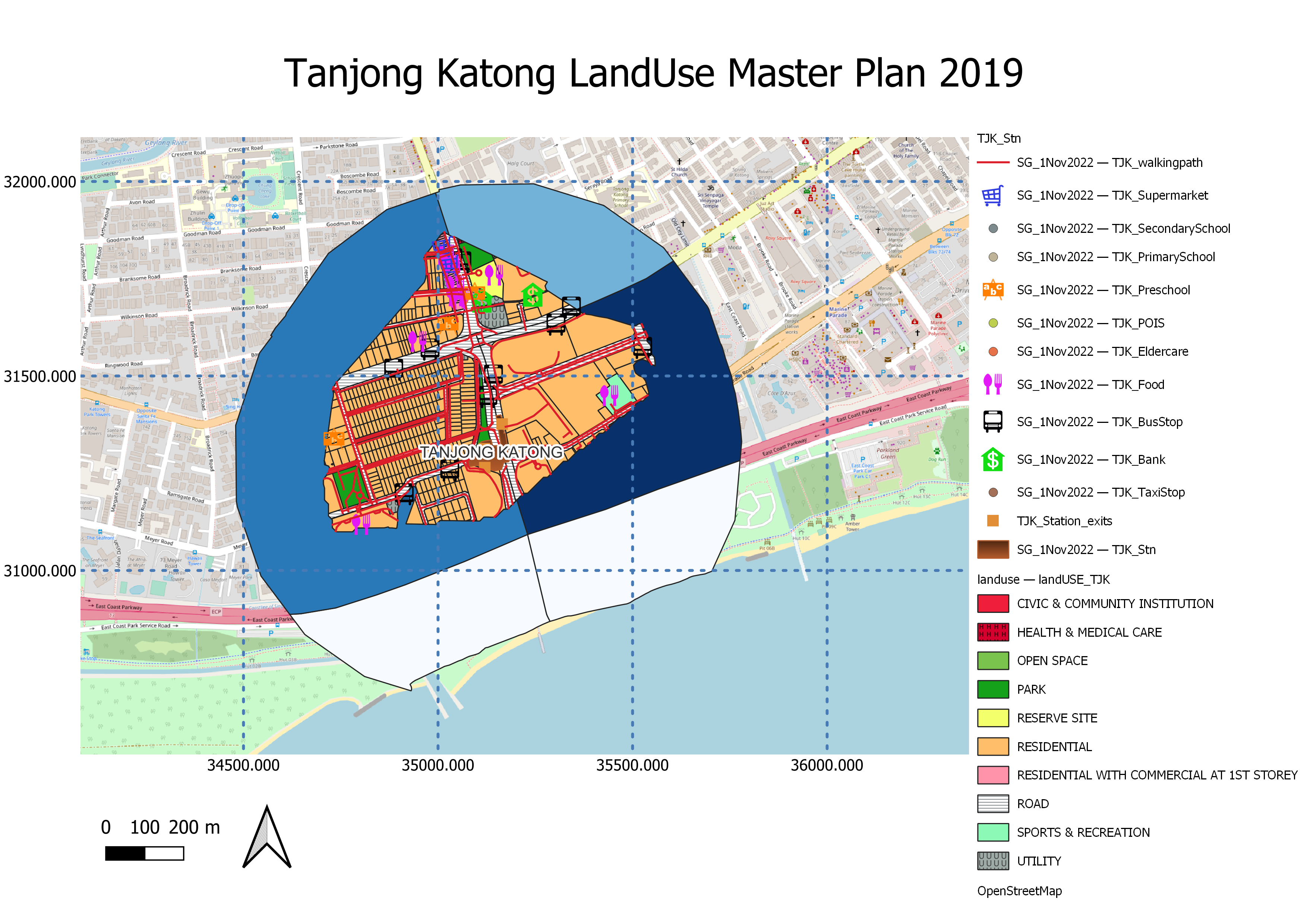
TJK station, being located within a residential area, has adequate amenities for residents to purchase food and necessities within 10 minutes by foot. In addition, there are bus stops near the station, increasing connectivity to other areas of Singapore.
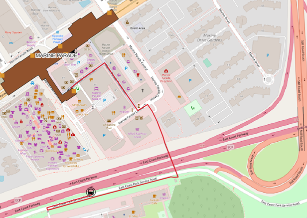
Marine Parade
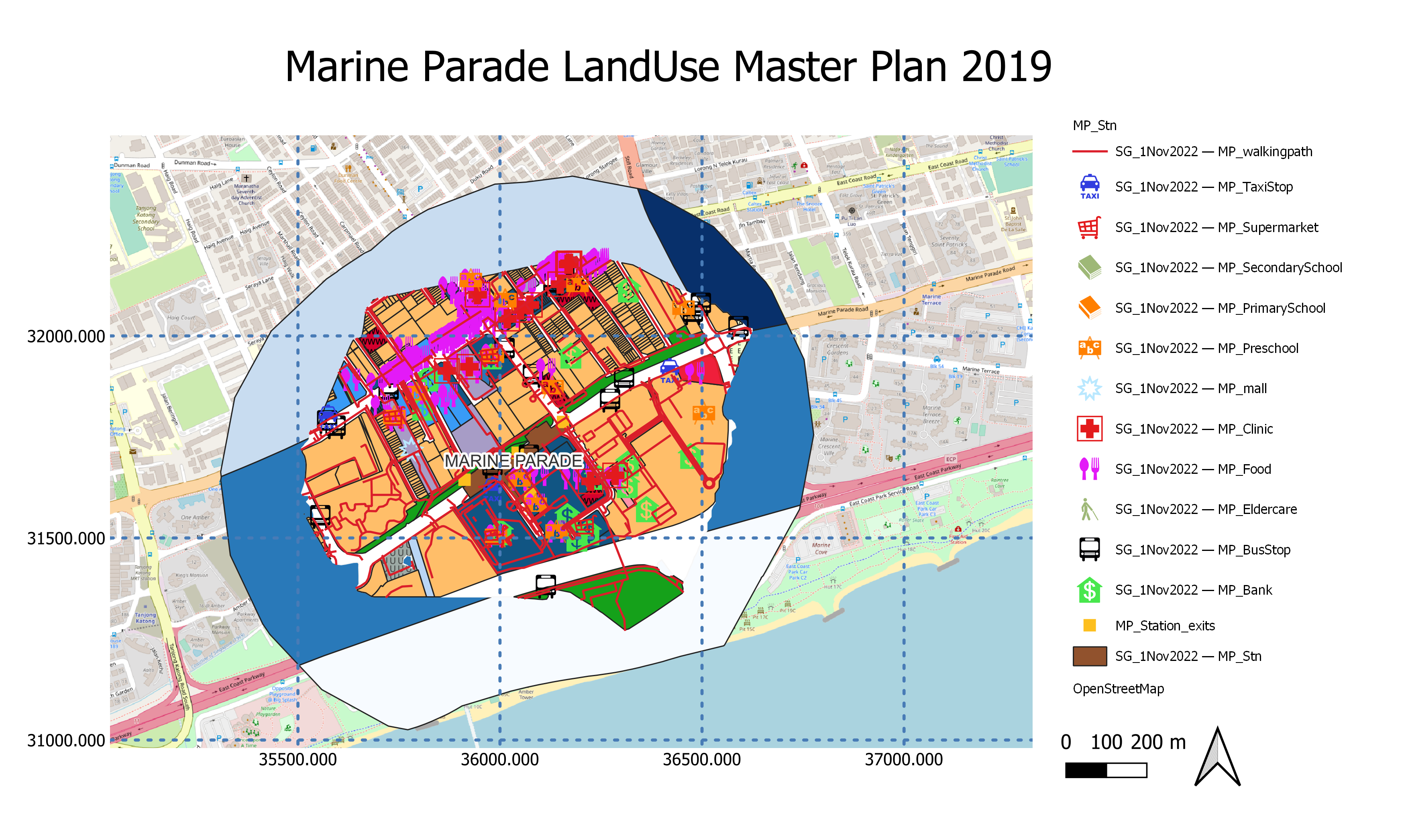
By the look of image above, we can see that MP area is well developed and filled with plenty of amenities and points of interest. It was said to be a hot spot for higher income citizens, but with a lack of MRT accessibility currently. With the TEL set to arrive in Marine Parade by 2024, new housing developments may become more attractive in the future.
Marine Terrace
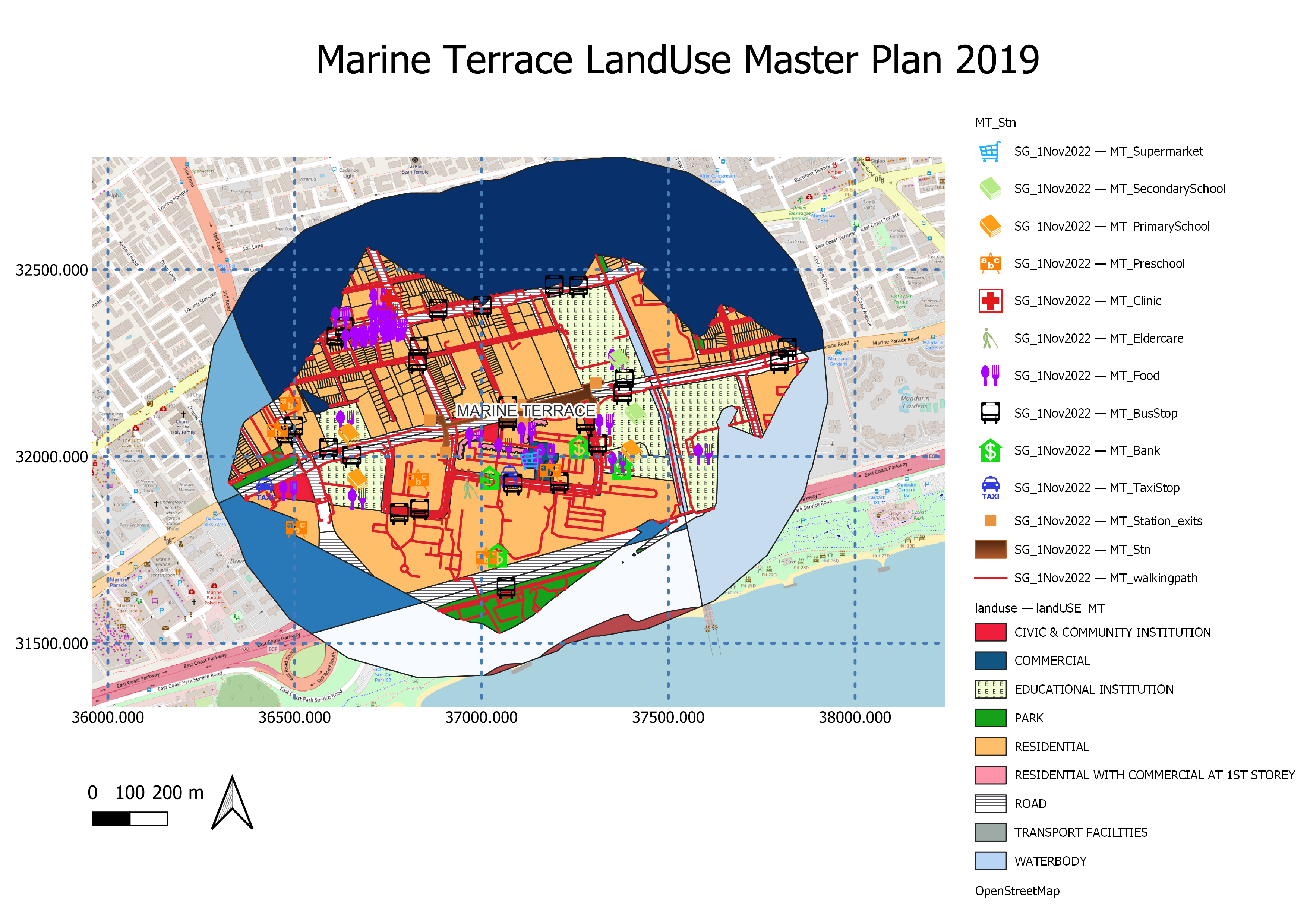
MT station is in the vicinity of schools, food and residential estates. Like TJK station, the amenities are adequate for residents to purchase food and goods within a 10 minutes’ walk. In addition, there are bus stops nearby the station, increasing connectivity to other areas of Singapore.
Siglap
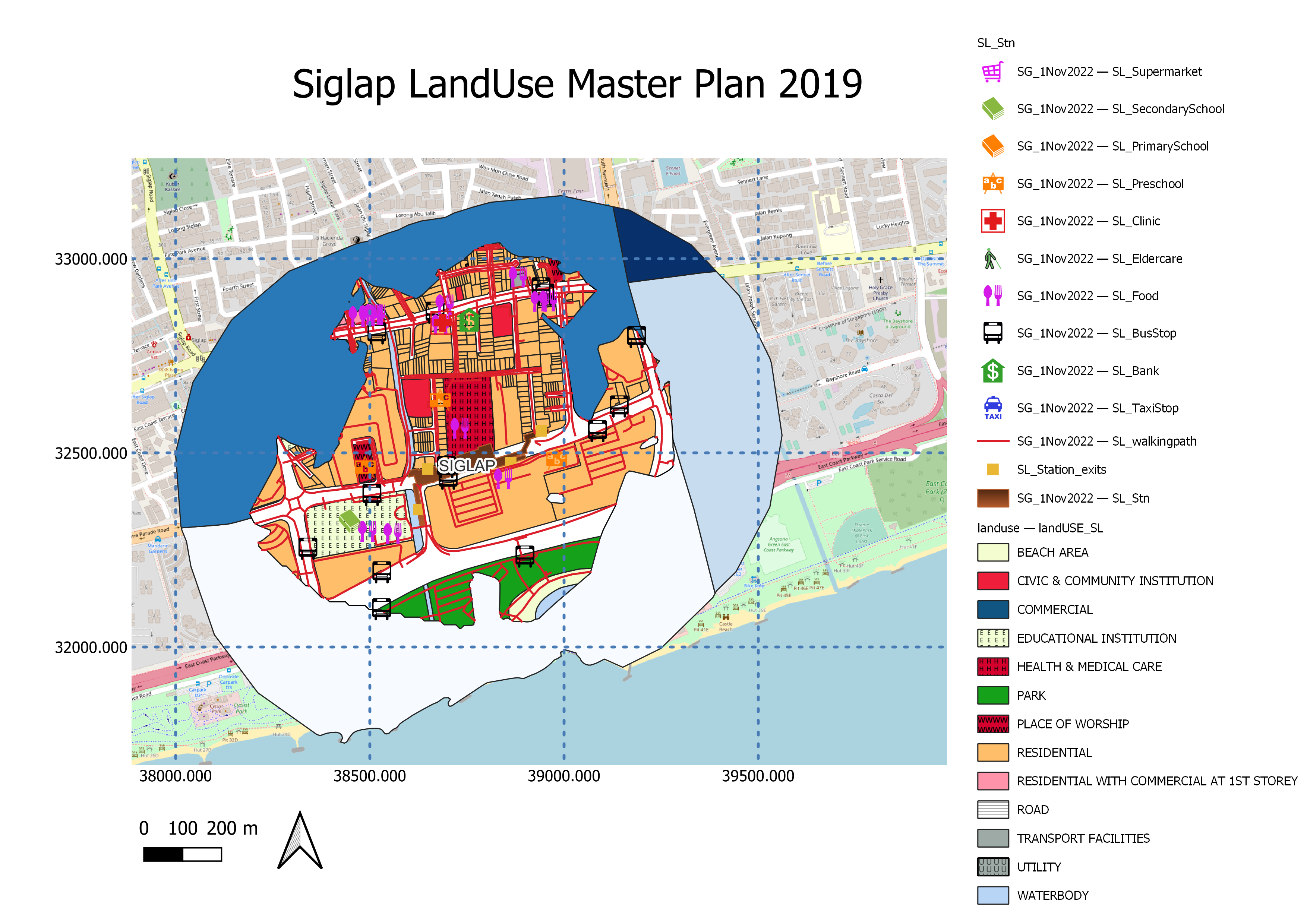
SL station being situated around residential and hospital areas, the amenities are adequate for residents to purchase food and goods within a 10 minutes’ walk. In addition, we recommend having some bicycle parking or rental facilities to encourage commuters to cycle to the nearby East Coast Park (ECP).
Bayshore
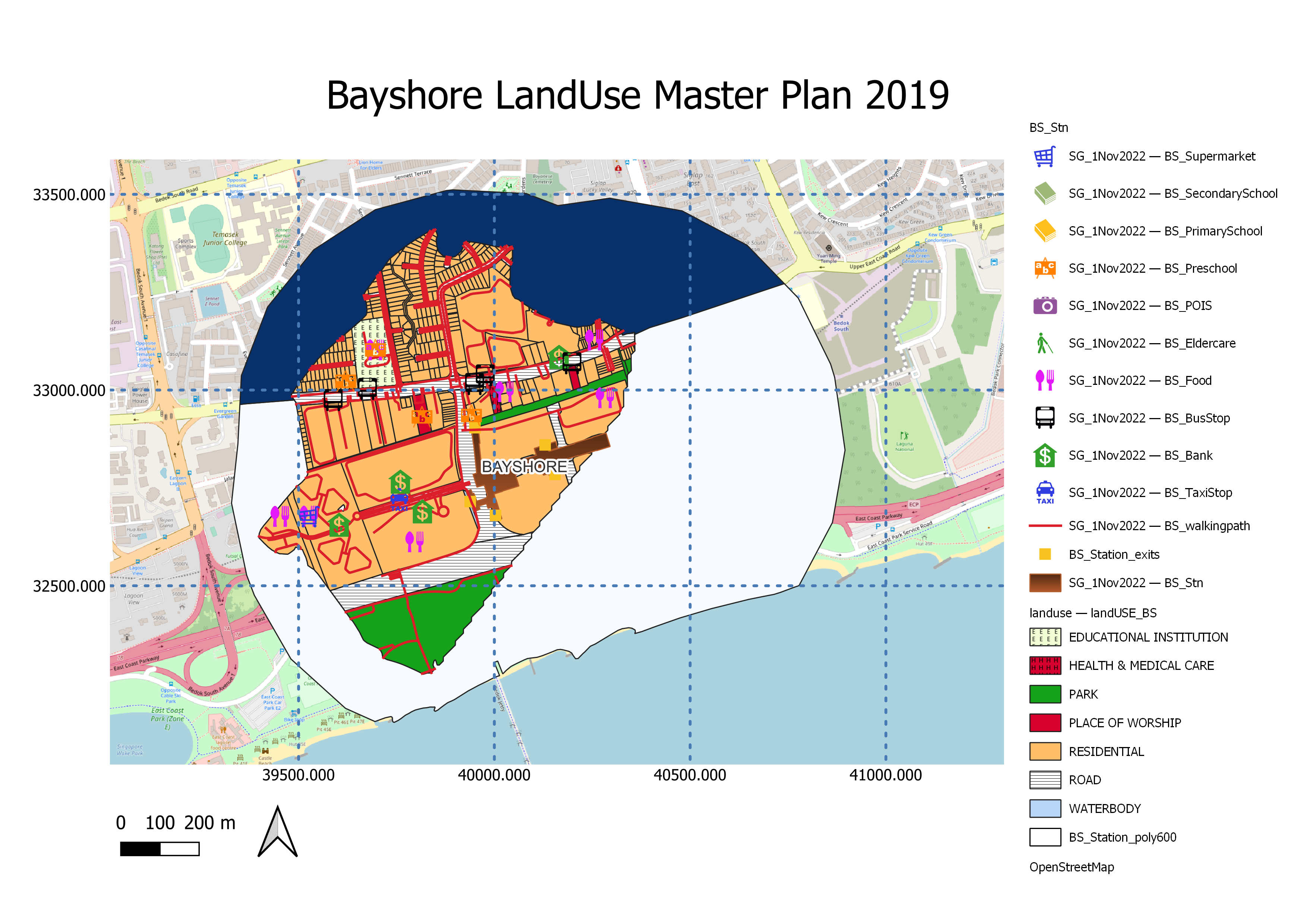
BS station is located on Bayshore Road, in the vicinity of several private housings and condominium estates around the Bayshore and Upper East Coast Area. The amenities are adequate for residents to purchase food and goods within a 10 minutes’ walk. Furthermore, Bayshore station is located close to ECP, we recommend having some bicycle parking or rental facilities to encourage commuters to cycle to ECP nearby.
Shortest Path to Bus Stops
We performed the Shortest Path Analysis on Marine Parade and Marine Terrace MRT stations due to its larger population amongst the other stations.
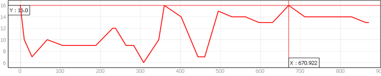
First, two random bus stops have been picked from each of the two MRT stations. The bus stop is the starting point and the MRT exit is the ending point. To compute the shortest route, the walking path layer was used as the network layer. And Shortest Path (point to point) from QNEAT3 algorithm was used to implement the Dijkstra-Search. Lastly, the difficulty of each returned path was being analyzed by using the elevation of the DEM Singapore layer and terrain profile tool. The results of the 4 paths analysed, rated with path difficulties from low (with relatively low elevation) to medium (with some degree of elevation) can be found below, along with the length of the path in meters.
Marine Parade - Bus Stop 1
Bus Stop 1: Shortest Path Analysis | Path Distance (Meters): 870 | Path Difficulty: Low
Bus Stop 1: Profile Analysis
Marine Parade - Bus Stop 2
Bus Stop 2: Shortest Path Analysis | Path Distance (Meters): 515 | Path Difficulty: Low
Bus Stop 2: Profile Analysis
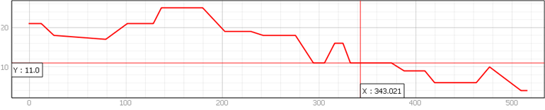
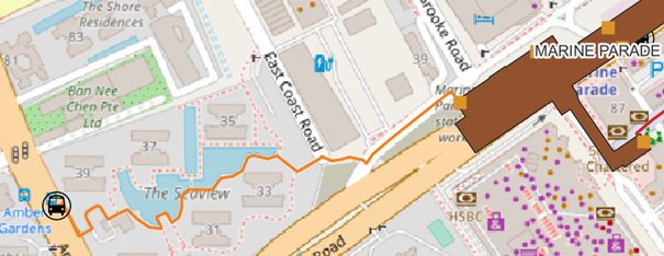
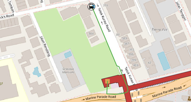
Marine Terrace - Bus Stop 1
Bus Stop 1: Shortest Path Analysis | Path Distance (Meters): 262 | Path Difficulty: Low
Bus Stop 2: Profile Analysis
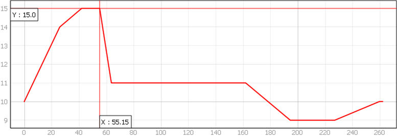
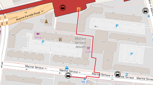
Marine Terrace - Bus Stop 2
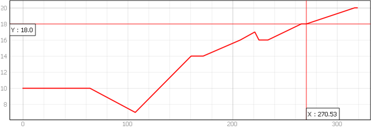
Bus Stop 2: Shortest Path Analysis | Path Distance (Meters): 319 | Path Difficulty: Medium
Bus Stop 2: Profile Analysis
Conclusion
The results of the analysis have shown several possible trends. Firstly, people tend to choose to live in areas with more facilities as we observed that areas with sufficient facilities tend to have a higher population density. The increased number of facilities within the vicinity brings added convenience to residents’ lifestyle, without having to spend additional time travelling to get their errands done.
Secondly, people are also more likely to choose to live at a house that is within 10 to 15 minutes to an MRT station by foot. If we were to observe, all the areas surrounding the MRT station consist of at least 90% of residential areas, except Founders’ Memorial and Tanjong Rhu station where they are situated nearer to the central area of Singapore and the land use did not allow for higher population densities. Staying near a MRT station brings connectivity to other parts of Singapore and will allow time saved to be allocated for better use.
Lastly, the findings of the analysis have been used to develop a comprehensive land use plan for the repurposing of Marina Bay Golf Course after July 2024. Incorporating the trends concluded above, amenities such as food, malls, banks, clinics and entertainment establishments has been planned to be included in the repurposed land area, attracting tourists to choose to stay in the integrated resort/hotel planned within a 10-minute walking zone, bringing additional convenience during their stay in Singapore.